Our motto: Hike more, worry less…
About
St Helena is a small British Overseas Territory situated in the South Atlantic Ocean. One of the remotest places on earth, it is also one of the most extraordinary places to visit. Its unique character and unspoilt beauty lies in contrasting and spectacular scenery, a rich cultural heritage and an environment extremely rich in biodiversity. These are just a few of the reasons why this remote jewel is a perfect location for active exploration and discovery.

St Helena Island is situated in the South Atlantic Ocean, at 15° 56′ south and 5° 45′ west. The nearest land is Ascension Island, which is 703 miles (1,125km) to the North West. It is 1 200 miles (1 950km) from the South-West coast of Africa and 1 800 miles (2 900km) from the coast of South America. A 47 square mile island, it is one of the remotest settled islands in the world. A sub-tropical paradise, it is also one of the most spectacular as far as contrast goes.
You can travel to St Helena by air or sea. Airlink flies once a week on a Saturday to St Helena.
Where To Stay
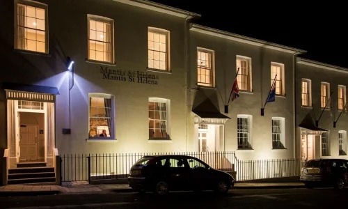
St Helena offers a range of accommodation options. There are currently several hotels and guest houses, bed & breakfast establishments as well as self-catering accommodation. It is advisable that booking of accommodation should be a prerequisite in advance prior to visiting the island.
Eco Trails SA can book your accommodation for you.
The Island
With its uniquely rich diversity of heritage-based attractions, both built and natural, St Helena offers many things to see and lots to do – from visiting the Georgian town to the rugged coastline, from the rolling hills to the stark yet striking geology at Sandy Bay. That’s the thing about this destination…there’s so much more to the island than you may think. St Helena is home to the most varied heritage and nature, breath taking views from the highest peaks, inviting waters, and 100% quaintness.
The Climate
The climate of St Helena is controlled by the South Atlantic High Pressure Cell and the Equatorial Trough. Despite the island’s locality within the tropics, its climate is kept mild and equable by the South East Trade Winds. The trade winds blow from high to low almost continuously making our weather so changeable. A dull rainy morning can often lead onto a bright sunny afternoon.
The four seasons are not recognised on St Helena, as there are no drastic weather patterns. The hottest months are between January and March and the coldest are between June and September, however our climate is suitable for a getaway all year round.
For much of the year, temperatures remain between 70-80°F (20-27°C) but nights and early mornings can get colder in the months of June, July and August. Rains usually begin from March to early May, with April being the height of the rainy season and again in July to September, with August being the height of this period.
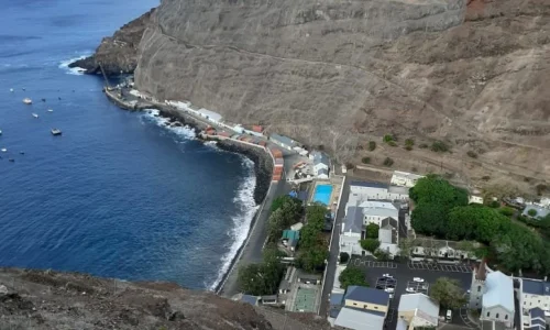
Temperatures in Jamestown range between 20°C – 32°C in the summer and 15°C – 26°C in the winter. The temperatures in the central areas are, on average, 5 – 6 degrees lower, which is why there are noticeable contrasts in climate between Jamestown (coastal) and the country areas. Jamestown can be sunny and lightly humid whilst areas like Longwood experience chilly mists and a higher rainfall.
Entry Requirements & Permits
All visitors must have valid passports, return tickets and pre-booked accommodation. A fee of £20.00 is payable for all visitors over 12 years of age when arriving at St Helena. Remember to have proof of your medical insurance with you.
Residence Permits
All visitors must have valid medical insurance for at least £175,000 which includes aeromedical evacuation or other means to pay for treatment to cover themselves for the duration of their stay, proof of which must be produced on arrival. If visitors wish to stay for more than 90 days they must apply for a residence permit, which can be issued for up to a period of 2 years.
Trails
All The Hikes On St Helena Are Green Flag Accredited Trails.
Post Box Walks
St Helena has 21 Post Box walks designed by the St Helena Nature Conservation Group (SHNCG) as an opportunity to access and enjoy the wide variety of landscapes, natural and man-made heritage of the island. Dedicated to exploring St Helena since 1993, the SHNGC promote awareness of the flora and fauna of both the terrestrial and marine environment of St Helena.
At the end of each walk is a ‘Post Box’ that holds a notebook to write your comments in and a stamp that many use as a souvenir. The distance of the 21 walks fall between 1.5 km – 12km, and time taken falls between 1hr 15 mins – 3 hrs 30 mins. It is always recommended to be accompanied by a guide.
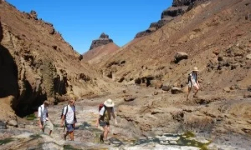
A volcanic outcrop in the South Atlantic Ocean, the island of St Helena is a 47 square mile sub-tropical paradise, with rolling hills and a rugged coastline, prime terrain for terrain for exploring on foot. Home to an impressively varied range of walks and trails for such a small area, the Island’s diverse landscapes – from mist-enshrouded cloud forest to ancient desert – offers national beauty at every turn.
Blue Point
A walk on the edge of the area known as the Gates of Chaos, with heavy erosion revealing the colours of the soils beneath. The wind is particular strong in this area of the island and has carved some spectacular erosion features.
Time & Distance: 40 mins each way, 3 km
Elevation: Between 550 and 600m
Rating: Effort 3/10 Terrain: 3/10
Diana’s Peak
A very popular walk with interesting and unique ecology. Diana’s Peak is the highest peak on St Helena at 2700ft (823m) providing stunning 360° landscape views across much of the island.
Time & Distance: 2.5 hours round trip, 3.8 km, 1.5 hours each way. 2.5 km
Elevation: 650 up to 823 m
Effort: 5/10 Terrain: 5/10
Cox’s Battery
A medium length walk that ends with good views of Turk’s Cap, The Barn, King and Queen Rocks and Prosperous Bay Beach. No steep climbs, but there are sheer drops each side of the wide ridge leading to the battery which can be unnerving.
Time & Distance: 45 mins down, 1 hour up, 4.8km
Elevation: 430 down to 280m
Rating: Effort 3/10 Terrain: 2/10
Flagstaff
An easy walk through pastureland, scrub and trees, with great views over the Island. Crosses Deadwood Plain, once the site of a Boer Prisoner of War camp and now the most important site for the endemic Wirebird.
Time & Distance: 45 min up, 30 min back, 6km
Elevation: 530 up to 700m
Rating: Effort 2/10 Terrain: 2/10
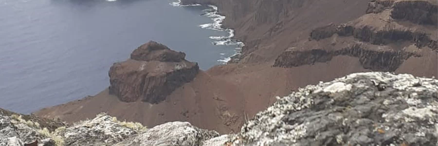
Great Stone Top
A very pleasant walk, passing Little Stone Top and above Shark’s Valley. There are stunning views of the south-east coast from Great Stone Top, one of the highest sea cliffs in the South Atlantic. It is a great place to enjoy the Red Billed Tropic Bird.
Time & Distance: 1 1/4 hours each way, 7km
Elevation: 555 dropping to 370 and then up to 494m
Rating: Effort 5/10 Terrain: 5/10
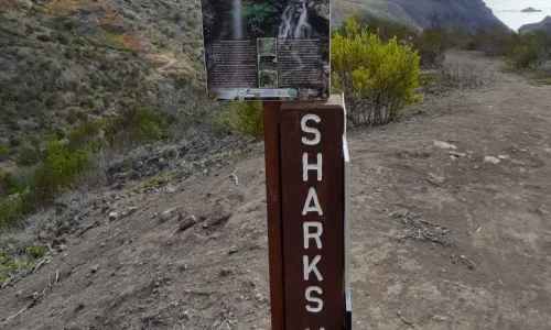
Shark’s Valley
This is a good hike, through an impressively deep valley containing one of the few constantly flowing streams on the island, ending at the rocky valley mouth. There are a few cascades to enjoy en route.
Time & Distance: 1.5 hours down, 2 hours back, 6km
Elevation: from 390m down to sea level
Rating: Effort 6/10 Terrain: 8/10
Gallery:
Price Available On Request
Contact 082 663 6168 or 064 523 1807
Email info@ecotrail.co.za
Disclaimer
All information adapted with permission of owner